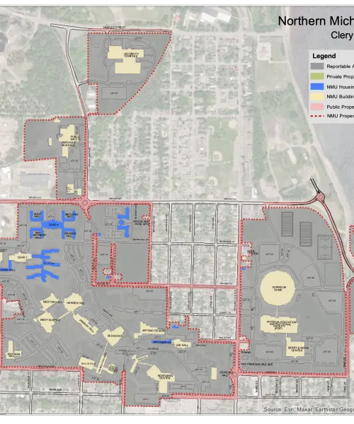
Clery Geography is the geographic area for which an institution is responsible for disclosing crime statistics. The image below outlines the Clery Act Geography for Northern Michigan University.
On-campus buildings or property
Any building or property owned or controlled by an institution of higher education within the same reasonably contiguous geographic area of the institution and used by the institution in direct support of, or in a manner related to, the institution’s educational purposes, including residence halls; and property within the same reasonably contiguous geographic area of the institution that is owned by the institution but controlled by another person, is frequently used by students, and supports institutional purposes (such as a food or other retail vendor).
Student housing
Any student housing facility that is owned or controlled by the institution, or is located on property that is owned or controlled by the institution, and is within the reasonably contiguous geographic area that makes up the campus.
Public Property
All public property, including thoroughfares, streets, sidewalks, and parking facilities, that are within the campus, or adjacent to and accessible from a facility owned or controlled by the institution.
Non-campus buildings or property
Any building or property owned or controlled by a student organization recognized by the institution; and any building or property (other than a branch campus) owned or controlled by an institution of higher education that is used in direct support of, or in relation to, the institution’s educational purposes, is frequently used by students, and is not within the same reasonably contiguous geographic area of the institution.
| Building/Property | Physical Address |
| NMU Concussion Research Clinic | 841 Washington St. Marquette, MI |
| Innovate Marquette Smart Zone | 101 W.Washington St. Suite #11 Marquette, MI |

NMU PD Patrol Area Map

